New BRC / BSBI Plant Recording Card on iRecord
Over recent months BRC have been working with the Botanical Society of Britain and Ireland to bring a ‘square bashing’ data input mode to iRecord. The results of this can be found at www.brc.ac.uk/irecord/enter-vascular-plants and a PDF overview of the functionality (in the form of a poster recently presented at the BSBI Scottish Recorders’ Meeting and the Annual Exhibition Meetings) is available here.
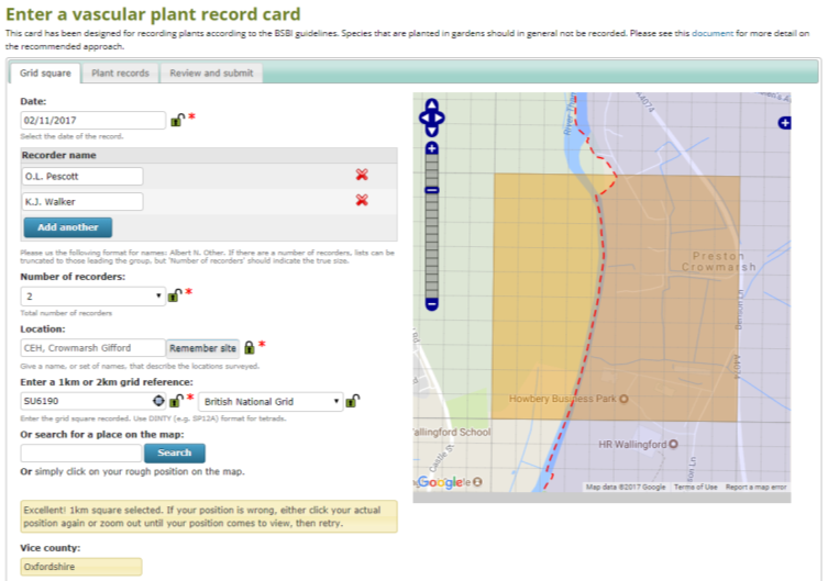
The development of the card has led to many improvements to what iRecord has to offer the plant recorder, and we have many other enhancements in the pipeline. The card allows one to enter lists of species at either the monad (1 x 1 km) or tetrad (2 x 2 km) levels, and also collects visit information, such as the number of recorders (independently from recorder names) and the time spent recording. We hope that such ‘metadata’ about recorders’ visits will be incorporated into future analyses, providing as they do some indication of the effort expended in a square.
Other enhancements to the iRecord interface include the ability to specify the vice-county when recording a ‘straddling’ square, the presence of vice-county boundaries on the map when selecting a square, and the ability to enter ‘visit’-level notes about the recording session.
The recording of the plant list for a square has also been developed in order to allow the entry of as much useful data as possible: recorders can enter finer-scale grid references for unusual finds (either 6-, 8-, or 10-figure grid references), with the ability to also enter GPS-derived precisions for 10-figure grid references, so that records are not entered with spurious accuracy. Six- and 8-figure references are assumed to represent the corresponding cells of the OS grid, and so have an automatic precision attached. Additional information that can be entered includes life-stage, status (i.e. planted, invasive etc.), standard measures of local abundance (e.g. DAFOR or counts), determiner names, altitude, comments, and of course the option to add a photo. The entry of names is supported by the standard iRecord auto-complete, allowing for the use of many forms of name abbreviations, including the popular strategy of typing just the first few letters of the genus and the specific epithet.
A final review screen provides the list, and a count, of species recorded, all additional information entered, and the vice-county boundary, thus allowing one to check that any finer-scale records entered are in the right place. Future enhancements will include the ability to access lists of saved cards (rather than going back into edit cards through individual species records), automatic checking of altitudes, new vice-county records, and suggestions for status based on geographic location.