iMammalia App

Designed to encourage recording of mammals in the wild. Records will be verified by experts and made available to help with mapping the distribution of European mammals.

With the iMammalia App, sightings can be recorded anywhere, with or without photos, and all records will be verified by experts and made available to help with mapping the distribution of European mammals. You can check and update your records online.

This version of the mobile application is set up to easily record mammals in any European country, but does not yet have all European languages included.

What's Flying Tonight App

An app developed in partnership with Butterfly Conservation and UKMoths, to help you identify what moths you see, based on your location and the date.

We make use of the millions of records gathered through Butterfly Conservation’s National Moth Recording Scheme, to provide an illustrated list of the larger moth species seen at this time of year in your area. With moth images, flight charts and the frequency that each species has been recorded based on your location and the date, What’s Flying Tonight can help with species identification.

Flower-Insect Timed Count (FIT Count) App

Spend ten minutes watching flowers and insects in good weather! Help assess changes in abundance of broad groups (e.g. bumblebees, hoverflies) of wild pollinators, from April to September.

This simple survey collects data on the total number of insects that visit a particular flower, ideally chosen from our list of 14 target flowers. FIT Counts can be done anywhere, including gardens and parks, in warm, dry weather any time from April to September. FIT Counts are suitable for all, in urban or rural locations.

Mammals - Species Recording Form

Please fill out the details in the three-step form below before clicking on the Save button to send us your record.

Please enter the species you saw and any other information about them.
*
 *

Select the date of the record.

*

Did you hear it, see it or see traces of it?.

How many you observed. (Should be set to 1 if you observed a field sign.)

Please provide the spatial reference of the record. You can enterthe reference directly, or search for a place then click on the mapto set it.
*

Provide the name of the site, ideally using one that is recognisable from map. Do not enter a postal address as the information you provide will be visible to others.

*
*

Please provide your first name

*

Please provide your surname

*

Please provide your email address. This will only be used to contact you if we require further information to verify the record.

Indicate your level of experience.

Tick this box if you have uploaded a photo and would like to receive confirmation of the identification - where this is possible.

TreeLogs

Personal details

Please provide your first name

Please provide your surname

*

Please provide your email address.* We will use your email address in case of any queries and to send you occasional updates about the project. You may opt out at anytime.

TreeLogs details
*
 *

Select the date of the record.

Please upload three photos of each observation.
Step 1
SpeciesPhotos
Photo 1: upwards Add photos
Photo 2: Left TreeLog (with the sign) Add photos
Photo 3: Right TreeLog (without the sign) Add photos

Targeting Revisits Maps for Grasshoppers, Craneflies, Ground beetles and Soldierflies


At the Biological Records Centre at UKCEH we use records submitted to Recording Schemes to calculate trends in these species. But – here’s the important point – because we’re looking for changes over time, we run our trend analyses only with records from sites visited in more than one year. There are many, many sites across the country that have records only from one year. (Here we describe a ‘site’ as a single 1km square, and use records from 1990 up to the current day.) If people revisited sites that previously had been visited in only one year, then we would be able to include many more sites in our analyses - and so we’ve created this mapping tool to easily show people where these sites are: the challenge is to turn the pink squares to green by revisiting them this year!

Each site (a 1km square) is classified according to its visits:

Colour

Key legend

Explanation

Bright pink

Targets for revisits

Sites that have records from only one year in the past – if these sites are revisited then they can be included in our trend analysis.

Pale pink

New in 2020

Sites that, for the first time, have records from this year. Next year these will become targets for revisits.

Bright green

Well recorded

Sites that already have records from multiple years – these sites are already included in our trend analysis, but of course records from these sites continue to be valuable.

Pale green

Successful revisits

Sites that used to only have records from a single year, but since this year have visits from multiple years and will now be included in our trend analysis.

Blank

Unrecorded

Sites that, so far, don’t have any records of grasshoppers and allies in our database.

(Strictly speaking, we base classifications on records submitted this year, so old records that have been submitted this year count as ‘new’ to the database. In most cases, ‘new’ records will be those made and submitted this year.)

Let us know what you think

Have you had a look at the Targeting Revisits Maps for Grasshoppers, Craneflies, Ground beetles or Soldierflies? Are they helpful for you and do they inspire you to record? Please let us know what you think via this feedback survey.

More information on the Targeting Revisits Maps

  • The Targeting Revisits Maps are provided to help inform where you might choose to record grasshoppers and allies based on patterns of recording in the past. It highlights sites (in bright pink) that have records from only one year in the past. Revisiting these sites would be helpful for analysis of species trends..
  • The maps include expert-verified data from the species covered by the relevant recording scheme (Grasshoppers and Allies Recording Scheme, Cranefly Recording Scheme, Ground beetle Recording Scheme and Soldierflies and Allies Recording Scheme).
  • There may be other records available that have not been passed to the recording scheme, so the maps may not represent all the data that are available. Please get in touch with the scheme organiser if you are aware of data that could be added to these datasets.
  • How are the maps updated? The Targeting Revisits Map uses the latest data from iRecord and is updated every few days. Be aware that recent records have not been verified, so this map should not be viewed as authoritative – see the Recording Schemes websites for Grasshoppers and allies, Craneflies, Ground beetles and Soldieflies and allies for more details.

More information on recording these species

  • Note that all records are valuable for understanding the distribution and trends of these species, where ever they are from.
  • It is especially valuable to submit ‘lists’ of species. A list is all the species you recorded at a location on a particular date, not just ‘special’ or notable species. Recording lists of species from repeated visits to the same site within and across years provides the best possible information for analysis of trends.
  • It is best to submit your records via iRecord so that they can readily be included in the Recording Scheme databases and will enable the Targeting Revisits Map to be updated promptly. You can use the iRecord website or iRecord app. The fully illustrated iRecord Grasshoppers app (currently only for Apple devices) provides support for recording grasshoppers and bushcrickets. All the records go to the same database.
  • Please only record species that you are confident of identifying, or where you can provide a photo (or sound recording) to help verify the records.
  • The Recording Schemes websites for Grasshoppers and allies, Craneflies, Ground beetles and Soldierflies and allies give more details about recording these species.


For further information please contact Michael Pocock Michael.pocock@ceh.ac.uk

The Targeting Revisits Maps were developed by UKCEH with support from NERC and the JNCC through the TSDA (Terrestrial Surveillance Development and Analysis) project.

We are grateful to Brian Valentine and Charlie Jackson for permission to use their images.

Primary image caption
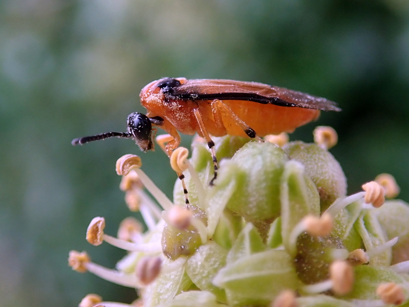
Hearing grasshoppers and bush crickets is one of the joys of summer. Records of these and related species can be submitted to the Grasshoppers and Allies Recording Scheme – and our new tool helps you work out where the records are most needed.
Primary image